Friday, July 29, 2011

From Old American to Canada

A short two hour hop from Spokane brings us into Newport, WA without incident (Does every state have a "Newport"?  Are there any "Oldports"? ... just curious...).  Our campground is called "Old American Campground" ...  and half of it is in Washington and the other half is in Idaho.  Everyone here is really nice.  We are greeted by Lois .. a really nice and friendly camp host, who suggests a really nice place to park, with wonderful views overlooking the river.  I drive up the steep slope to my spot ...  to get into the spot a bit of expert maneuvering is required (I have to dodge a post and a tree on either side).  My neighbor to the left runs out and helps get me in ... Lynda and I have met yet another really nice couple (Ray and Vicci).  We hook everything up and have a nice cocktail with new friends. ...  Very nice!  Here are a couple of pictures of the view from our front window:


One of the "must dos" in this area is called the Selkirk Loop.  This is a 150 mile loop that goes from Washington into Canada and back into Idaho.  It is a beautiful drive if a bit long.  Thick forests of cedar and spruce line the road broken by wide beautiful meadows and the occasional farm.  It travels along rivers and lakes with a new experience around nearly every corner.

We get to the Canadian border and stop at the kiosk on the Canadian side.  I remember visiting Canada in the 60s.  We drove across the border and there was a nice friendly visitors center to stop at and get maps and other information.  There were no accusatory looks and unfriendly questions...  The border guard was a typical government agent ... "just the facts ma'am."  Are you now or have you ever been a criminal?  Are you bringing in a gun? a knife? fruit? unclean underwear? the wrong deodorant? What is you business here?  How long will you be staying?   To this last question, we answered that we were just on a day trip to drive the Loop ... his reply ... "It usually takes 2-3 days to drive the Loop" ...  Oh, I'm sorry officer ... you got me there ...  Undoubtedly, I am lying about my plans ... I really am sneaking into Canada and plan on smuggling out moose burgers ....  So much for the nice welcome experienced in the 60s ...  this is the new century ... the suspicious, unfriendly, century ...  Oh by the way ... Welcome to Canada!

The Loop takes you up around Kootinay Lake.  It really is magnificent.  We have lunch in Nelson, BC.  We go into a couple of places and after looking at the prices settle on a Subway.  We pay $14.00 for a six inch sub  and a six inch sub salad ... when we get home our credit card charges us an additional .47 cents for the international fee ...  Everything in Canada is expensive (apparently the cost of the government taking away your individual rights in exchange for lifetime "care".)  Gasoline is $1.30 a liter (we filled up in Washington and wait to fill up again in Idaho so avoided this expense).  By the way $1.30 a liter equals $4.91 a gallon (1 gallon = 3.78 liters ...  $1.30 X 3.78 = $4.91 per gallon) ...  compare to $3.69 in Idaho ...  The difference is in additional taxes. 

Back to the Loop.  We take a Ferry over the lake (did I mention that it is a really large lake?) with marvelous views on all sides.  As soon as we drive on, we hop out of the jeep and go into the cafe for coffee.  The proprietor stiffs us on the US to Canadian exchange rate so we pay $8.80 for two small coffees ....  again, welcome to Canada ...  the people there were not terribly friendly ...  they were happy to have our dollars, but you get the impression they all wished you would just stay at home and mail them the money. ...  Back to the Loop (Did I mention how beautiful it was?).  Here are a few pics:


The border crossing back into the US was only a bit better than that going into Canada.  You present your passports and then the questions start ...  What are you bringing back into the US?  Alcohol?  Tobacco?  Weapons?  Drugs?  Are you a terrorist?  Did you meet with any terrorists?  Where do you live?  What is the weather like there?  What color is your house?  Who was the President during the Hoover administration?  What was Mickey Mantle's hitting average?  How many passes did Stretch Johnson catch in the 1946 NFL season?  Welcome home ...   ???  What a world we live in!!

We stay close to home for a couple of days and watch TV ... the park has cable and Jim the really nice maintenance manager helps us figure out how to get more than 13 channels ....  we get the whole load of 72 ....  Whoopie ...  we can watch "Pawn Stars".

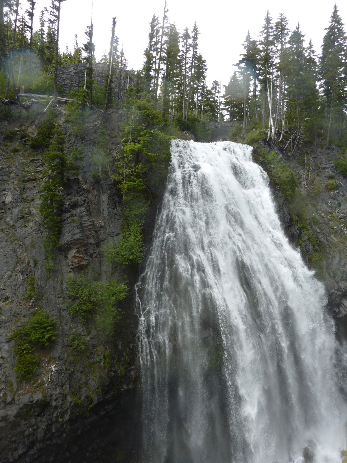
We hear about a grove of old growth cedars in Northern Washington and are off again.  The last 13 miles is over a really bad dirt road ...  We are really appreciative of our 4X4 jeep ...  When we arrive at the parking spot it is a trail head... so we suit up and grab our walking sticks ...  Did we mention how much hiking we have done lately?  The hike is steep and it rains on us off and on the entire way ...  but we see some great scenery although the cedar grove is a bit disappointing.  Here are a few pics:


Lynda is pretty pooped by the end of the trail ...  ok ... me too.  We are looking forward to our next adventure ...  Until then ... do what you love and you will never have to work.

Wednesday, July 20, 2011

From Desert to Oasis


From Desert to Oasis

This past 10 days we have had two stops:  One in Othello, WA (located in central WA) and then a couple days in Spokane (In Eastern WA).

We called ahead to our “resort” (think very crowded RV Park) to make sure that the directions on the gps were the same as those given by the locals and came in contact with Madge  yes just like the cartoon character … a crotchety, grumpy, old lady who obviously wanted off the merry-go-round … but was too ornery to jump.   Nevertheless, it was a good thing we called … the gps was routing us all over god’s half acre.  It turns out the gps thought we were too heavy for the road, but it was the only way to the RV park. …  The gps was going to give us a great tour and we were never going to arrive.

We were not disappointed when we finally arrived (with the gps complaining the entire way that we were too heavy for the road … finally turned it off) and were not disappointed. … There stood Madge  at the counter to check us in …  seemed downright pissed that we were going to camp for free for a week (have the right membership for this one).  Told us to go find our own spot …  located a really nice spot with some grass next to us and across a little road.  Unfortunately, the next day a bunch of rowdy campers showed up with tents and the nice grassy areas became tent cities, with the drunks staying up and being loud until 1 a.m. several days running.  Late night TV is not really very good …  but slept until 9 or so each morning.  It was still annoying that the park did not enforce any rules regarding quiet evenings …

This park had mainly local folk from the Seattle area that came to fish and boat on Potholes Reservoir.  They were the boys with toys bunch …  you know the type …  boats, tents, and beer.

Across the street from our RV park is a really nice state park right on the reservoir …  We broke out the Segways and glided (remember that’s what riding a Segway is called) across to the park.  Had a wonderful day.  Potholes Reservoir is really a beautiful place.  Here are a few pics.


We took off for Spokane, WA on Monday to go to the local Cummins dealer for annual maintenance on the Coach (we call it a coach when we have to spend money on it … makes it feel better).  Sixty miles into the trip a red light comes on and a blaring siren sounds (I guess this is to make sure you don’t miss the light).  We pull over (on the 90 Fwy – no easy feat) and get down the book to decipher the alarm.  It turns out it sounds when the air pressure in one or both brake cans falls below a safe level. …  Just great … maybe no brakes!  I get back on the Freeway and drive two more miles to the rest area (a lot safer place to stop … luckily the brakes work and we stop safely).  We call up the warranty folk and after speaking with the absolutely blondest person in the world, they hook us up with a repair guy.  He arrives an hour later and crawls under the rig (we call it a rig when it is being troublesome) … he is a lot skinnier than we are and slides about with ease.  He has a little gauge that detects leaks in the air line … it detects nothing.  He finally comes into the RV and I show him what the gauges are doing .. bouncing all over the place with the alarm going on and off sporadically.  He pulls the gauge and tightens the wiring … apparently a gauge problem and not a brake problem … three hours later we are on our way again … happy times!

Arrived for our appointment and hooked up at the dealership.  A bit of freeway noise (it is right off the 90), but otherwise fine for a couple of days.  The dealership is friendly and responsive.

To pass the time we take Cody (our dog) and go to Manito Park.  Spokane has beautiful parks and this one is a gem!  It has a large lake with ducks and geese, large grass and tree areas, and wonderful walking/running pathways.  We had a great time walking around for over an hour.  Cody enjoyed all of the new sights and smells.


The next place we went is our blog “mystery destination.”  Here are a few pictures to help you figure out where we are:


We really loved this campus.  It is set in a small to medium sized town only 16 miles from Spokane.  It is quaint, friendly, and welcoming.  For those of you who don’t recognize Jen’s alma mater this is Eastern Washington University in Cheney, WA.

Until next time …  keep doing what you love.

Wednesday, July 13, 2011

"THE MOUNTAIN'


THE MOUNTAIN

The trip from Elma to Ashford was supposed to be easy, a quick couple of hours.  First we had to get out of our camping spot (we had pulled through the first time, but someone was now parked in back of us and there was a line of lovely trees right in front of us).  We did manage it  … just (only a couple of branches were casualties of the campaign) and pulled into the road.  When we stopped to hitch up the jeep we noticed we were leaking water from the compartment …  a gallon or two this time.  This is from an apparent leak that we can’t find.  It will stop leaking for days even a week and then appear again … sometimes a drop or two … sometime a deluge … this was a deluge.  We mopped up the compartment and the leak decided to go hide again. … fine … on with hitching up the jeep.  Did I mention we were stopped in the middle of the road in the RV park?  Sure enough some idiot with a huge fifth wheel decided he couldn’t wait another five minutes for us to hitch up and pulled around us … missed by less than an inch!

Finally ready to take off for Ashford at the foot of legendary Mount Rainier, we load the address into the gps and head out.  The gps takes us out to the I-5 and north into Tacoma, then on some city streets just for fun and finally, just so we get some extra practice driving a forty foot rig while towing another 16 foot jeep behind (20 feet with the tow bar), it takes us to a roundabout.  We haven’t seen a roundabout since our days living in Massachusetts (where the traffic engineers are registered sadists).  One of them must have moved here to Washington.  Round and round we go … all 60 feet of us … supposed to take the third exit … if we can get there.  We finally get out of the city again and are on our way.  The gps apparently loses our signal and stops talking to us at the exact moment we reach an intersection …  which way to go?  We make our best guess and quickly realize we “chose poorly.”  We are waiting for our bodies to explode like on Indiana Jones, but instead the ever friendly gps tells us that to correct our mistake, it is taking us back to the city and all the way around again for another go at it (two hours out of our way).  I find a wide spot in the road and take the rig into a U-turn.  Lynda covers her eyes and mumbles something incoherent.   Surprise (to both of us)!  The rig makes the turn … barely …and we are back on route.  We arrive at our campground 15 minutes later to be greeted by a bridge made by trolls for goats.  We drive down the dirt lane (no backing up or turning around this time) and there it is … the little narrow bridge that could.  The camp host is on the other side of the bridge smiling and waving us over (It looks a bit like a scene from Deliverance).  I look at the bridge (it might be 103 inches wide and we are 102 inches) and release the brake.  The bridge groans and complains, but over we go … We have finally arrived.

The campground is beautiful.  Our site is under some trees and surrounded by streams.  Deer wander through the campsite.  Here is a picture.


We also had some great flowers in the camp.


The downside of all this beauty is that phone and TV service is nil and internet service (from the host’s provider) is spotty and works only when the stars are in alignment (apparently this does not happen very often).

During our stay we want to visit at least two sites:  Mount Rainer National Park and Mount Saint Helens National Monument.

The next day we set out for Mount Rainer.

Towering 14,211 feet from the valley floor Mount Rainer is a massive, mighty, and majestic mountain.  Unlike other mountains in other ranges, it, by itself, dominates the landscape.  The locals refer to it simply as The Mountain.  No other explanation is needed.  Its bulk is so dominant and its presence so awesome that it makes its own weather and influences the weather patterns of several states.  As the moist air from the Pacific Ocean begins to move inland it is held by the mountain against its western slopes.  Eventually, the bits of moisture gather until they release themselves into torrents of rainfall … all on the western side of the mountain … precious little escapes to move inland across Washington State.  On a clear day The Mountain can be seen from Vancouver, Canada to the north and Portland, Oregon to the south.  It has 26 different glaciers and 36 square miles of snow & ice fields.  Five rivers begin on its glaciers flowing throughout the region below.

While seemingly benign, it is a stratovolcano … considered one of the most dangerous volcanoes in the world. It occupies a place of dubious honor on the Decade Volcano list.  Should it blow, the melting ice would create lahars that would devastate much of the surrounding, occupied, area.  Located in the ring of fire it is only a short distance (50 miles), as the crow flies, from its sister, Mt. Saint Helens.  Rainier has two volcanic craters at its peak, each over 1000 feet in diameter:  truly a sleeping dragon lying quietly on its treasure, while humans play among its scales.

Here are some pictures:


Kim standing on the slopes of Mount Rainier.  Apparently there is no sliding ... I'm really trying to comply!


Lynda stands by a cutaway in the snow, showing how deep it still is in July ...  still around 13 feet deep!


The area around Mount Rainier.  Really beautiful!

 Mount Rainier in the distance.  Taken from the east side, as the western slopes were socked in with clouds.


A fox near the road after leaving Paradise Inn at Mt. Rainier.


A Marmot sits on a mound of snow watching the cars go by.
We took a great hike to the "patriarch trees" ... an old growth forest with huge trees that is a marvelous experience ...  Some of the trees are 1000 years old.

 Two old growth red cedar trees.

One of many Falls in the Park surrounding Rainier.  When the snow melts, the water flows!

We rested a day and hung around the camp.  The host (a really nice guy, as it turned out) and owners were wonderful.  This is one of the best campsites we have been in … clean, well groomed, and in a wonderful setting … did we mention the deer?

The next day we were off to Mount Saint Helens … or what was left of it.

While it is only 50 miles over to Mt. Saint Helens as the crow flies, those of us traveling by non-aerial means have a two-hour drive.  One of the things we discovered on our way over is that we could have made the drive from Elma to Ashford in about ½ the time without going through the city and on a much better and easier road.  Sometimes the gps is kind and sometimes it is not … who knows the mind of the gps?

Mount Saint Helens has four visitor centers, each run by a different governmental entity and each claiming poverty and charging their own admission fees!  The best of the lot is run by the U.S. Forest Service and sits right at the base of the mountain.  Make sure you see the movie at this location (skip all the other visitor centers) and take the short hike to see the area around the mountain.

For those of you who have forgotten, Mt. Saint Helens (named after a friend of Vancouver) used to have an elevation of 9,677 feet and now has an elevation of 8,365 feet following a volcanic eruption on May 18, 1980.  The eruption was spectacular with ash circling the earth and nearly a square mile (actually .7) of material being blown into the air.  It was also tragic with 57 people losing their lives and over 250 homes lost along with 47 bridges and miles of rail and highway.

The interesting thing about Mount Saint Helens, aside from the awesome power of the earth to reshape itself, is that it is still erupting.  Within the blown crater a small “mountain” is rising from the continual eruptions (see pictures).  In addition, a new glacier formed on the mountain the winter following the eruption and it has grown to an average depth of 300 feet with 650-foot deep ice found in some places.  This glacier is now as large as those on Rainer that are thousands of years old … all in thirty years …  Seems that some geologic events do happen in very short periods of time!

Here are a few pics.

You can barely see Mt. Saint Helens in the background.  The good Samaritan taking our picture together, missed the point, but still a nice pic of us!


This mountain used to look nice and rounded ...  Note the huge crater in the middle.


Lynda with Mt. Saint Helens in the background.

This shows the new "mountain" growing inside the volcanic crater.  That is not a cloud, it is smoke from the still active volcano.


All in all one of our best weeks!

Tuesday, July 12, 2011

Searching for the Greeks

This week we have been in Olympic National Park in Washington. 

Wikipedia gives the following blurb about the park:  Olympic National Park is located in the U.S. state of Washington, in the Olympic Peninsula. The park can be divided into four basic regions: the Pacific coastline, alpine areas, the west side temperate rainforest and the forests of the drier east side. U.S. President Theodore Roosevelt originally created Mount Olympus National Monument in 1909 and after Congress voted to authorize a re-designation to National Park status, President Franklin Roosevelt signed the legislation in 1938. In 1976, Olympic National Park became an International Biosphere Reserve, and in 1981 it was designated a World Heritage Site. In 1988, Congress designated 95 percent of the park as the Olympic Wilderness.

Like most of our parks, the public has access to a fraction of the park (probably a good thing) … but that being said, you can see a great deal from the road that winds around the park.  The park gets around 180 inches of rain a year (with Mount Olympus getting 200 inches).  For those of you not familiar with the history of this area … everything here was apparently named by a Grecophile … However, it is not (repeat) not in Greece … and while there are a few things here that are similar with Greece (both have a mountains near the shore (a tall peak named Olympus) and have a mainland on a penensula, these similarities are insignificant compared to the differences: (1)  Greece apparently has a series of gods living on its Mt. Olympus, and no gods have been reported in Washington … at least none wearing a chiton and throwing lightning bolts. (2) Greece is a series of islands with a small mainland in the Mediterrainian Sea (think nice warm weather), and (3) Washington in wet …  Olympic NP is famous for its rain forest (think wet … the trees here are covered with moss and other fungi that live in the damp).

We, being apparently either godlike ourselves or just lucky (probably the latter), were in the park on one of the few days without rain.  Enjoy a few of the pics we took. 


 Here we are at Port Angeles with Vancouver Island in the background
 Lynda overlooking Crescent Lake in Olympic National Park.
 Just loved this gnarly tree!
 Ocean scenery in Olympic National Park

Had lunch at Port Angeles.