
THE MOUNTAIN
The trip from Elma to Ashford was supposed to be easy, a quick couple of hours. First we had to get out of our camping spot (we had pulled through the first time, but someone was now parked in back of us and there was a line of lovely trees right in front of us). We did manage it … just (only a couple of branches were casualties of the campaign) and pulled into the road. When we stopped to hitch up the jeep we noticed we were leaking water from the compartment … a gallon or two this time. This is from an apparent leak that we can’t find. It will stop leaking for days even a week and then appear again … sometimes a drop or two … sometime a deluge … this was a deluge. We mopped up the compartment and the leak decided to go hide again. … fine … on with hitching up the jeep. Did I mention we were stopped in the middle of the road in the RV park? Sure enough some idiot with a huge fifth wheel decided he couldn’t wait another five minutes for us to hitch up and pulled around us … missed by less than an inch!
Finally ready to take off for Ashford at the foot of legendary Mount Rainier, we load the address into the gps and head out. The gps takes us out to the I-5 and north into Tacoma, then on some city streets just for fun and finally, just so we get some extra practice driving a forty foot rig while towing another 16 foot jeep behind (20 feet with the tow bar), it takes us to a roundabout. We haven’t seen a roundabout since our days living in Massachusetts (where the traffic engineers are registered sadists). One of them must have moved here to Washington. Round and round we go … all 60 feet of us … supposed to take the third exit … if we can get there. We finally get out of the city again and are on our way. The gps apparently loses our signal and stops talking to us at the exact moment we reach an intersection … which way to go? We make our best guess and quickly realize we “chose poorly.” We are waiting for our bodies to explode like on Indiana Jones, but instead the ever friendly gps tells us that to correct our mistake, it is taking us back to the city and all the way around again for another go at it (two hours out of our way). I find a wide spot in the road and take the rig into a U-turn. Lynda covers her eyes and mumbles something incoherent. Surprise (to both of us)! The rig makes the turn … barely …and we are back on route. We arrive at our campground 15 minutes later to be greeted by a bridge made by trolls for goats. We drive down the dirt lane (no backing up or turning around this time) and there it is … the little narrow bridge that could. The camp host is on the other side of the bridge smiling and waving us over (It looks a bit like a scene from Deliverance). I look at the bridge (it might be 103 inches wide and we are 102 inches) and release the brake. The bridge groans and complains, but over we go … We have finally arrived.
The campground is beautiful. Our site is under some trees and surrounded by streams. Deer wander through the campsite. Here is a picture.

We also had some great flowers in the camp.


The downside of all this beauty is that phone and TV service is nil and internet service (from the host’s provider) is spotty and works only when the stars are in alignment (apparently this does not happen very often).
During our stay we want to visit at least two sites: Mount Rainer National Park and Mount Saint Helens National Monument.
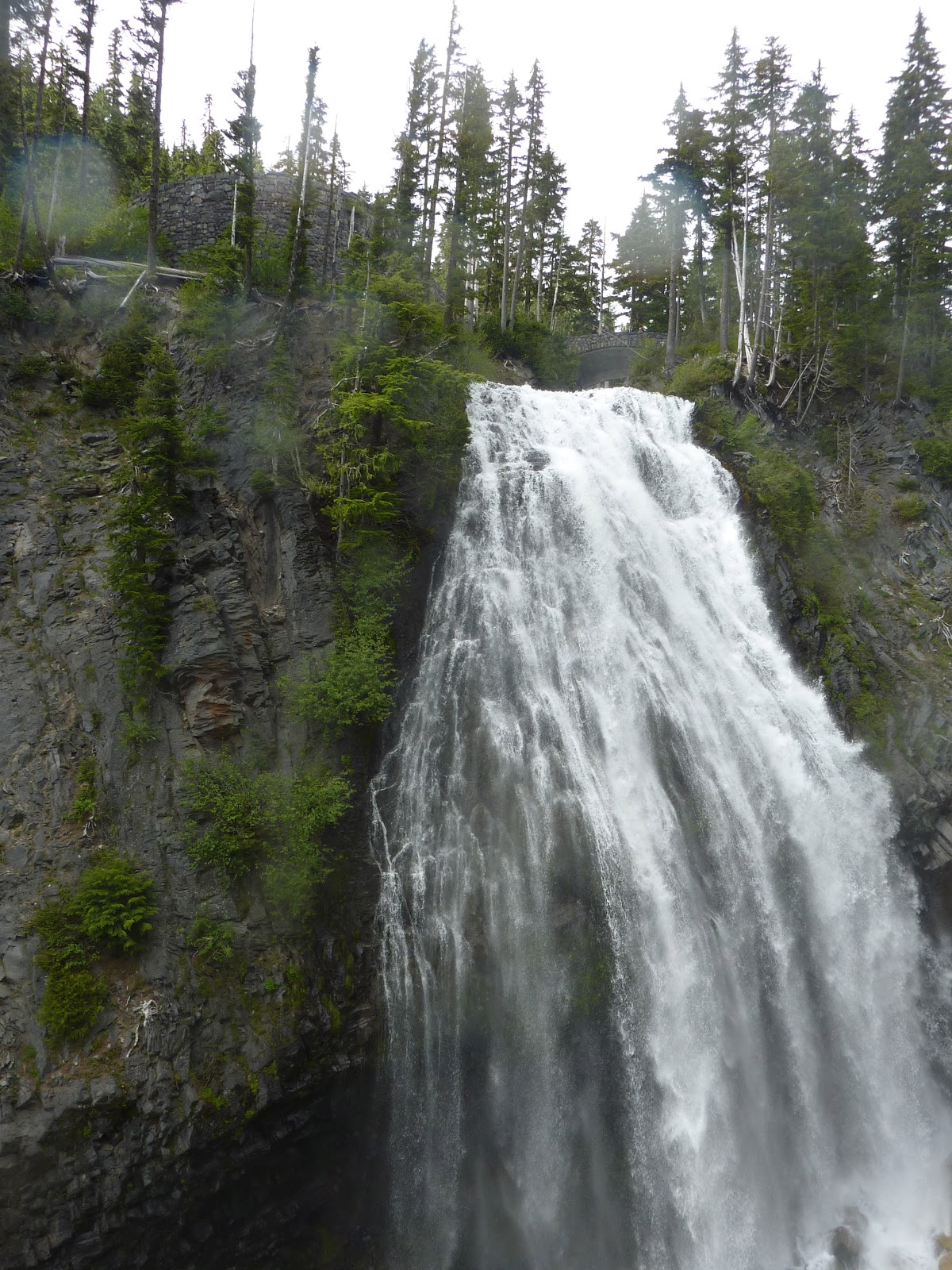
The next day we set out for Mount Rainer.
Towering 14,211 feet from the valley floor Mount Rainer is a massive, mighty, and majestic mountain. Unlike other mountains in other ranges, it, by itself, dominates the landscape. The locals refer to it simply as The Mountain. No other explanation is needed. Its bulk is so dominant and its presence so awesome that it makes its own weather and influences the weather patterns of several states. As the moist air from the Pacific Ocean begins to move inland it is held by the mountain against its western slopes. Eventually, the bits of moisture gather until they release themselves into torrents of rainfall … all on the western side of the mountain … precious little escapes to move inland across Washington State. On a clear day The Mountain can be seen from Vancouver, Canada to the north and Portland, Oregon to the south. It has 26 different glaciers and 36 square miles of snow & ice fields. Five rivers begin on its glaciers flowing throughout the region below.
While seemingly benign, it is a stratovolcano … considered one of the most dangerous volcanoes in the world. It occupies a place of dubious honor on the Decade Volcano list. Should it blow, the melting ice would create lahars that would devastate much of the surrounding, occupied, area. Located in the ring of fire it is only a short distance (50 miles), as the crow flies, from its sister, Mt. Saint Helens. Rainier has two volcanic craters at its peak, each over 1000 feet in diameter: truly a sleeping dragon lying quietly on its treasure, while humans play among its scales.
Here are some pictures:

Kim standing on the slopes of Mount Rainier. Apparently there is no sliding ... I'm really trying to comply!

Lynda stands by a cutaway in the snow, showing how deep it still is in July ... still around 13 feet deep!

The area around Mount Rainier. Really beautiful!

Mount Rainier in the distance. Taken from the east side, as the western slopes were socked in with clouds.

A fox near the road after leaving Paradise Inn at Mt. Rainier.

A Marmot sits on a mound of snow watching the cars go by.


Two old growth red cedar trees.
We rested a day and hung around the camp. The host (a really nice guy, as it turned out) and owners were wonderful. This is one of the best campsites we have been in … clean, well groomed, and in a wonderful setting … did we mention the deer?
The next day we were off to Mount Saint Helens … or what was left of it.
While it is only 50 miles over to Mt. Saint Helens as the crow flies, those of us traveling by non-aerial means have a two-hour drive. One of the things we discovered on our way over is that we could have made the drive from Elma to Ashford in about ½ the time without going through the city and on a much better and easier road. Sometimes the gps is kind and sometimes it is not … who knows the mind of the gps?
Mount Saint Helens has four visitor centers, each run by a different governmental entity and each claiming poverty and charging their own admission fees! The best of the lot is run by the U.S. Forest Service and sits right at the base of the mountain. Make sure you see the movie at this location (skip all the other visitor centers) and take the short hike to see the area around the mountain.
For those of you who have forgotten, Mt. Saint Helens (named after a friend of Vancouver) used to have an elevation of 9,677 feet and now has an elevation of 8,365 feet following a volcanic eruption on May 18, 1980. The eruption was spectacular with ash circling the earth and nearly a square mile (actually .7) of material being blown into the air. It was also tragic with 57 people losing their lives and over 250 homes lost along with 47 bridges and miles of rail and highway.
The interesting thing about Mount Saint Helens, aside from the awesome power of the earth to reshape itself, is that it is still erupting. Within the blown crater a small “mountain” is rising from the continual eruptions (see pictures). In addition, a new glacier formed on the mountain the winter following the eruption and it has grown to an average depth of 300 feet with 650-foot deep ice found in some places. This glacier is now as large as those on Rainer that are thousands of years old … all in thirty years … Seems that some geologic events do happen in very short periods of time!
Here are a few pics.


Lynda with Mt. Saint Helens in the background.

All in all one of our best weeks!
Very Cool!!
ReplyDeleteThis is AWESOME!!!! :) :)
ReplyDelete